
Trace a Jackson Township Street by Address
Jackson Township has no citywide resident roll, and its postal labels can point to several nearby communities. Start with the full street address. Run it through USPS ZIP Code Lookup to confirm the preferred postal city and ZIP, then open the Stark County Real Estate Search for a Jackson Township address. The county profile supplies the permanent parcel number, site address, listed owner, tax-mailing fields, legal description, sales clues, and a map link. Those are property-record leads, not a declaration that every person at the location is public.
Keep the parcel number and legal description from the first result. They carry the trail when a street suffix, direction, postal city, or number differs in an older source. A listed owner can be tied to a recorded deed, while an address can be checked in a dated reverse directory. The strongest Jackson Township street directory result is therefore a documented chain with dates, not a single screen capture.
- Confirm the complete Jackson Township address with USPS and record the postal label returned for that address.
- Search the Auditor/Treasurer portal by the Jackson Township address, then save the parcel number, legal description, site address, and listed-owner field.
- Open the linked map and inspect the selected parcel and its immediate Jackson Township street segment. Each additional parcel needs its own profile.
- Use the sale clue, owner name, parcel, and legal description in the Recorder path to locate the recorded instrument.
- If a known individual needs registration confirmation, use Ohio Voter Search with that name and Stark County. It is not a streetwide browser.
- For an older Jackson Township address association, take the normalized address to Stark Library’s Haines Criss+Cross directory and then the matching alphabetical directory.
Search the Jackson Township Street Directory
For a Jackson Township street directory, the Auditor/Treasurer portal is the practical starting point because the basic Address mode accepts a number, street term, or direction. Its official help says to leave off the street suffix for broad street-name results. An ending wildcard is implied, so a bare street term can return matching streets and addresses. Long result sets are capped at 500 displayed results and paginate, which means a full street needs careful narrowing or paging rather than an assumption that the first screen is complete.
| Real Estate Search field | Input and purpose | Verified limit or format |
|---|---|---|
| Parcel ID | Full or partial permanent parcel identifier. | Full example is 10 characters without spaces; * can be used within or around a partial value. |
| Owner | Full or partial owner name for a parcel lead. | Use LastName FirstName with no comma; an ending wildcard is implied. |
| Address | Address number, street, suffix, direction, city, and ZIP fields. | Omit suffix for the broadest street-name result. |
| Advanced Search | Residential/Agricultural or Commercial group, then a dependent criterion. | At least one criterion is required; values can be added, edited, or removed. |
| Map mode | Select a parcel with Basic or Advanced Search, then open Maps. | The selected parcel is highlighted for map review. |
For a Jackson Township address, the result grid identifies Parcel #, Owner, Parcel Address, Land Use #, and Land Use Description. Open the profile before drawing any conclusion. It separates the physical parcel from the tax correspondence fields and provides the records that make a Jackson Township street directory investigation repeatable.
- Parcel
- A permanent Jackson Township property identifier connecting a profile, tax information, and map selection.
- Situs address
- The physical street address shown for a Jackson Township parcel. It is distinct from the tax-mailing address.
- Plat
- A recorded map of lots, blocks, streets, or easements that can help interpret a legal description.
- Criss-cross directory
- A historical directory arranged by street address so an address can lead to a listed name.
Map Jackson Township Street Parcels
The Stark County GIS route is a map check after, not before, the property search. The county provides Basic and Advanced Parcel Viewers, a GIS Hub, data downloads, and the Auditor search. From a selected Jackson Township profile, open Maps and the parcel is highlighted. Drag a box to zoom, pan by dragging, use full extent when needed, and use the back and forward controls to revisit selections.
Map controls can select, identify, measure, and choose parcels by a distance buffer. They help define the lots along a Jackson Township street segment. They do not label a complete household. Open each selected lot’s property profile, preserve the parcel number, and compare the result with a Recorder instrument when the question is ownership or a date of transfer.
Note: Historic map evidence for Jackson Township is also available through pre-1940 “660” maps, 1940s–1997 tax maps, scanned surveys, and aerial resources when a modern address trail stops.
Compare Jackson Township Street Records
For a Jackson Township street directory, address-keyed sources serve different functions. The property profile supplies the current county identifier and tax association. The map supplies parcel context. The Recorder supplies instruments, and the Township can hold address-specific zoning material. A historical directory can place a listed name at an address at publication time. Combining those records is more reliable than treating any one of them as a streetwide list of current occupants.
| Address-keyed source | Keeper | Street evidence | Access and important boundary |
|---|---|---|---|
| Real Estate Search profile | Stark County Auditor/Treasurer | Parcel, listed owner, site and mailing fields, legal description, sale and map leads. | Public web after disclaimer; reference material, not proof of all people at the site. |
| Tax search | Stark County Treasurer | Parcel, owner-name, or property-address tax query. | Public web; it does not replace the recorded instrument. |
| Parcel and GIS map | Stark County GIS/Auditor | Selected parcel, adjoining boundaries, historic-map context. | Public viewer; confirm a map identifier in the profile and Recorder records. |
| Recorded instruments | Stark County Recorder | Deeds, mortgages, easements, plats, and other recorded land documents. | Public index or counter; confirm live image and copy conditions for a document. |
| Zoning certificate or file | Jackson Township Planning/Zoning | Address, project, applicant, plans, and decision trail. | Use the portal or a targeted request; it is not a household roster. |
| Haines Criss+Cross | Stark Library | Historical address-to-listed-name association. | Exact local shelf run is not published online; verify an edition at the library. |
Use the parcel number and legal description to join county sources within Jackson Township. Use the street name only as the discovery path. That distinction helps when a street’s postal city changes, a parcel is split, or a historic directory uses a different local label.
Follow a Jackson Township Street Deed Chain
The Stark County Recorder’s search instructions divide the path into a current search for 1982–present and archive search for 1809–1981. For a Jackson Township street, begin with the Auditor profile’s sale clue and legal description. In the Recorder index, find the current owner as a grantee around the transfer date, then confirm the legal description, document number or book/page, and displayed party roles in the instrument. The prior seller becomes the next grantee search.
That process produces a chain of recorded property control, not a list of residents. Keep the recording date, instrument type, legal description, and source note at every handoff. Mortgages, releases, plats, easements, affidavits, and conveyances may explain why an address trail changes. When a Jackson Township title trail does not resolve an older document online, take the parcel, legal description, and prior document clue to the Recorder counter or call the office for the historic index or image route.
Check Jackson Township Street Zoning Files
County land records do not replace the Township’s local project file. Jackson Township zoning resources can identify the district and its public records route can be used for a known address and date range. Ask for existing zoning certificates, applications, site plans, hearing notices or minutes, staff material, inspection records, and final action. A narrow request is more useful than asking the Township to assemble a new street list.
The public iWorQ permit lookup is limited to Permit # and Premises Affected, with headers for Permit #, Premises Affected, Status, and View. It uses reCAPTCHA, and no unfiltered browse, earliest year, or result detail was verified. A filing may name an applicant, project, or adjacent owners, but it does not establish a current occupant or an approved outcome.
Jackson Township’s permit-search screen shows the address-oriented route available before a targeted records request.
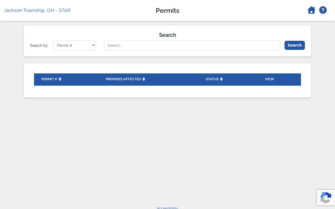
Use a premises address or permit number when available, then retain the returned status and date with the underlying Jackson Township record request.
Find Past Jackson Township Street Listings
For a Jackson Township historical address, Stark Library’s Family & Local History department holds the Haines Criss+Cross directory and the Canton City Directory. Use Haines for the reverse route: locate the closest available year, read the street-address sequence, capture the exact street spelling, number, and listed name, then move to the alphabetical directory for the household context. The exact Haines shelf-year run is not published online, so verify the edition with staff rather than filling a gap with an assumed year.
This is the Jackson Township street directory’s historical layer. Search more than one likely publication label because township addresses may be associated with Canton, Massillon, North Canton, Canal Fulton, Clinton, or a rural area in different records. A directory listing is tied to the publication date. For the fuller collection geography and entry-reading method, see the Jackson Township city directory collections.
Note: A directory can show a listed address-name association at publication time, but it cannot establish every household member or present status.
Verify Jackson Township Street ZIP Labels
A postal city is a mail-routing label, not a township boundary certificate. Jackson Township tax-district parcel results include ZIP labels such as 44216, 44614, 44646, 44647, 44705, 44708, 44718, 44720, and 44721. The research does not treat that discovery set as a USPS service-area map. A Canton or Massillon line can still belong to a Jackson Township parcel, and a Township address may use another nearby postal name.
Run the actual address through USPS and compare it with the parcel profile, permanent parcel number, legal description, and GIS context. This extra check prevents a city label from being mistaken for a Jackson Township property jurisdiction. It also keeps a historical street search from rejecting an older directory entry solely because its publication used a different locality name.
Use Jackson Township Street Voter Records Carefully
For a Jackson Township name search, Ohio Voter Search requires a first name, last name, and county, with Stark County selected for Jackson Township. It returns registration, precinct, and polling-place information for a match. It is useful only after a person’s name is already documented through an appropriate record. Its conditional street-name refinement is part of an individual search, not a public tool for browsing everyone along a street.
Ohio law makes voter registration forms and the statewide database public records with important exclusions. Social Security and license information, phone numbers, email addresses, confidential registrations, and protected addresses are not to be requested or republished. Ballot choices are not a voter-file field. For an uncertain or older election record, the Stark County Board of Elections is the human channel for a focused public-records request.
Set Jackson Township Street Directory Limits
The key limit is easy to miss: the property profile lists an ownership or tax relationship, not every person at an address. Its site address and tax-mailing address are separate fields. A mailing address may belong to a correspondence recipient, fiduciary, or another tax contact. Owner Occupancy Credit, Homestead Exemption, and inspection information are assessment items with dates and scope, not a complete current-household list.
Use a source only for what it documents. The Auditor profile is an address and parcel lead. GIS shows parcel geometry. A Recorder instrument records a land transaction. A zoning filing documents a project trail. Haines places a listed name at an address in a historical edition. Utility accounts, protected voter addresses, court-sealed material, and motor-vehicle address data are not a proper substitute for those records.
Lawful use. Use Jackson Township address records only for lawful personal, family-history, property, or civic research. Do not use them to stalk, harass, or harm anyone.